••
UN Approves Resolution to Adopt Equal Earth Map Projection Reflecting Africa’s True Size
•2 min read•3 sources
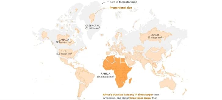
The United Nations General Assembly has passed a landmark resolution to shift away from the traditional 16th-century Mercator map projection in favor of the 'Equal Earth' projection. Led by Togo and supported by the African Union, the initiative seeks to correct long-standing geographical distortions that significantly underrepresent the true landmass of the African continent. The resolution passed with an overwhelming majority of 164 votes in favor, signaling a major shift in how the world is visually represented in official and educational contexts.
The traditional Mercator map, while useful for navigation, has long been criticized for exaggerating the size of landmasses near the poles while shrinking those near the equator. Under the Mercator projection, Greenland appears roughly the same size as Africa, despite Africa being nearly 14 times larger in reality. The new Equal Earth projection provides a more accurate representation, showing that Africa is approximately three times the size of the United States or Canada, thereby challenging centuries of skewed global perceptions.
Togolese Foreign Minister Robert Dussey, a primary advocate for the change, characterized the resolution as a vital step in addressing colonial-era legacies. He argued that the continued use of distorted maps reinforces outdated power dynamics and minimizes the physical and geopolitical presence of the Global South. While the United States was the sole nation to vote against the resolution, calling it an 'ideological distraction,' six other nations abstained, and many Western powers, including France and the United Kingdom, joined the majority in support.
Following the vote, Togo has announced plans to update its national geography curriculum and educational materials by the end of this year to reflect the Equal Earth projection. The United Nations is now encouraging other member states and international organizations to follow suit, ensuring that future generations are taught a more factually accurate view of the world. While the resolution does not impact current maritime or aerial navigation practices, its adoption marks a significant victory for African diplomacy and the global movement for accurate representation.